An ArcGIS GeoPlanner scenario is a single, unique alternative plan for consideration in the planning process. Scenarios contain features that are imported or sketched into a hosted feature layer in your organization. A GeoPlanner project contains at least one scenario and usually contains multiple scenarios created by various team members. All scenarios associated with a project have the same layer structures and symbol sets, and all scenarios are visible to project team members.
This topic describes how to work with scenarios and understand their functionality in GeoPlanner.
Create a scenario
When a project is created, a default scenario named Scenario A is automatically created and set as the active scenario. The active scenario appears as the first item in the Contents pane. All features imported or sketched into scenarios are internally tracked with an ID for the project and scenario.
You can create a scenario in a project if you are the project owner or are granted access to it. Scenarios have a title, summary, description, and tags. Complete the following steps to create a scenario:
- At the top of the application, click the scenario drop-down arrow and choose Create.
The Create Scenario dialog box appears.
- Type a title, summary, description, and tags for the new scenario.
- Click Create.
A scenario is created using the same feature template you specified when the project was created and will become the active scenario.
Open an existing scenario
You can access scenarios in the scenario drop-down menu. All project team members can open any scenarios associated with the project. Complete the following steps to open an existing scenario:
- At the top of the application, click the scenario drop-down arrow and choose Open.
The Open Scenario dialog box appears.
- Click Open on the scenario you want to open.
The chosen scenario is displayed on the map and will become the active scenario.
Edit scenario properties
You can change the scenario title, summary, description, and tags to help your team members better understand a scenario's characteristics. Complete the following steps to edit scenario properties:
- At the top of the application, click the scenario drop-down arrow and click the Scenario Properties icon
 .
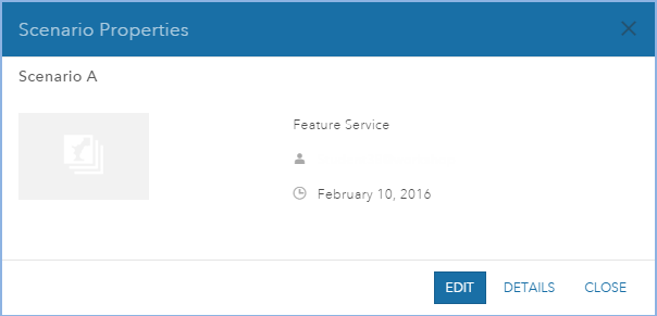
. - On the Scenario Properties dialog box that appears, click Edit.

- Change the title, summary, description, and tags for the scenario.
- Click Save.
Note:
If the Editors can only update and delete the features they add option is unchecked for the template feature layer, any project team member can edit any scenarios associated with the project. However, if this option is checked, only the user who created the scenario can edit it, and the Edit button is not available to other users on the Scenario Properties dialog box.
Delete a scenario
If you have more than one scenario open in your project, you can remove a scenario from your active project, or delete it from your organization. When you remove a scenario, it is deleted from the active project but can be opened again in the future. When you delete a scenario, the scenario item and all features in it are permanently deleted from your organization. Project members can remove any scenario, but can only delete scenarios they created. Complete the following steps to delete a scenario:
- At the top of the application, click the scenario drop-down arrow and click the Remove Scenario icon
 next to the scenario you want to remove or delete.
The Remove Scenario icon
 is unavailable if you only have one scenario in your project.
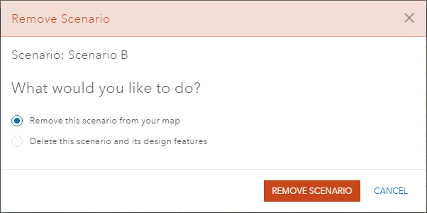
The Remove Scenario dialog box appears.

- Choose one of the following actions:
- Click Remove this scenario from your map to remove the scenario from the active project, but keep it in your ArcGIS organization. You can add it back when you want.
- Click Delete this scenario and its design features to permanently delete the scenario and all data it contains from your active project and your ArcGIS organization.
Note:
The Delete this scenario and its design features option is only available to the scenario creator or organization administrator. If you are not the scenario creator or the administrator, this option is unavailable on the Remove Scenario dialog box.
Set an active scenario
GeoPlanner allows you to open multiple scenarios in a project. However, only one scenario is active at a time. All sketching, analysis, and evaluation tools work on the active scenario. Therefore, it is important to know which is your active scenario and set it appropriately. Complete the following steps to set an active scenario:
- At the top of the application, click the scenario drop-down arrow.
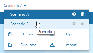
A list of the scenarios that your project contains appears with additional options.

- Click a scenario to set it as the active scenario in your project.
Duplicate a scenario
The Duplicate tool allows you to copy all features associated with the active scenario to a new scenario with a different name. This tool is useful when you want to save a scenario at different stages of your work and keep different versions of your design. All feature geometries and attributes, excluding attachments, are copied to the new scenario. Complete the following steps to duplicate a scenario:
- At the top of the application, click the scenario drop-down arrow and click Duplicate.
- Type a title, summary, description, and tags for the new scenario on the Duplicate Scenario dialog box.
Scenarios must have unique names, and attachments are not copied.
- Click Save.
Features associated with the active scenario are copied to the new scenario. The new scenario is now the active scenario.